Last weekend was an action-packed adventure weekend for us here at Flow North. We thought we would share the highlights of our trip to the town of Peace River for three busy days.
Thursday night: York Boat Captain Book Launch
I held my first official book launch for York Boat Captain – 18 Life-Changing Days on the Peace River with the help of the wonderful people over at the Peace River Museum, Archives and Mackenzie Centre. It went very well, as I expected, and it was a pleasure to chat with everyone, answer questions about the book and the boat, and see some old friends. (Blog posts here and here.)
Friday, Aug 16: Peace River Extreme Adventures Camp
As a part of the Paddle the Peace event, I teach canoeing for youth — a program we call Paddle the Peace Junior. Last year, the tiny rural school of Keg River benefitted from the program, and this year, it was offered for the youth of Peace River through the town of Peace River’s Extreme Adventures summer camp. We had an instruction day in July, which went very well, and this was the second one. Thanks to everyone at the town who made this possible — the kids all had a great time and learned canoeing skills, safety and even a little teamwork.
Saturday, Aug 17: Canoe Instruction
Paddle the Peace is actually a 2-day event for us; the first day is canoe lessons for adults. In order to accommodate more people, we have one group in the morning (lunch is provided) and another group in the afternoon (supper provided). We had such great people, in canoes and kayaks, who toughed it out despite the wind and waves on the lake! We reviewed canoe strokes, steering, teamwork, stability, getting in and out, and plenty of safety items, including a quick on-the-grass demonstration of the T-Rescue — a great way to help canoeists who have flipped.
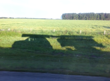
I love seeing the shadows of all the boats loaded on our vehicle and trailer.
Paddle the Peace: the Main Event! Sunday, Aug 18
As in years past, Flow North helps out by making canoes, kayaks and equipment available to people who need them! If a family didn’t have enough paddles, we lent them one. We lent PFDs to a mom for her kids. I always give the safety briefing on the bus before everyone goes out on the water, and with such a large group — about 100 paddlers! — I reminded everyone that it’s Sunday morning, so relax and be patient while others are boarding their boats. The whole process actually went very smoothly, as we staggered the departure of the two morning shuttles a little to eliminate a bottleneck of boats and people on the Shaftesbury shore.
A highlight of the day was the brunch at Strong Creek, provided by DMI, which allowed us to eat, chat and get to know one another. I think everyone agreed it was time well spent. On the whole, the day went remarkably well and nearly finished without any rain — just a downpour at the very end! My only regret: we were too busy to take pictures! Go to the Facebook page to see some posted there.
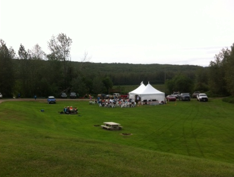
Looking down on the brunch tent and happy paddlers…
Let me not forget to thank everyone who worked so hard — over 20 volunteers — and funders who made the event possible. 🙂
– Shell Canada Peace River
– Daishowa-Marubeni International Ltd. (DMI)
– Travel Alberta
– Peace Regional Economic Development Alliance (PREDA)
Municipalities:
– County of Northern Lights
– Northern Sunrise County
– MD of Peace
– Town of Peace River
Well, mosquito season is upon us, and Darren came across this article which explains how to set up a very quick and easy mosquito deterrent for your backyard: an oscillating fan. Mosquitoes aren’t very good flyers, and we all know that a mild breeze is enough to keep them at bay. On a calm evening, why not make your own breeze with a fan! Of course, this won’t work when you’re on your canoeing trip, but it will work when you’re out in the backyard getting your equipment ready, like testing your survival gear (part 1, part 2, part 3)!
You can read the full article here.
We’ve been busy with some canoe instructing lately. If you’re in or near the town of Peace River, I believe there is one spot left for a youth for the town’s Extreme Adventures camp on August 16th. Call the Town to sign your child up. If you are an adult interesting in getting some lessons, you can partake in the half-day lessons on Saturday, August 17th, at Leddy Lake. This is a part of Paddle the Peace — check out this page for more info.
We are getting quite booked up for events such as canoe parties, so if you are thinking of having one, please contact us soon or we won’t be able to fit you in!
Hope you are all enjoying your summer so far!
Summer is such a busy time! I came across this page of Camping Hacks and thought I would share it. Some are completely impractical for canoe or kakak trips, but several are usable, such as the tin-can bread, the toilet paper holder, the pre-made coffee bags and the tic tac boxes for spices. And if someone can tell us what’s in Mountain Dew that makes it GLOW like that, that would be great! (Crazy!)
We are busy getting ready for some canoe lessons for a Girl Guide group next week! It is going to be a lot of fun!
Remember, we don’t offer scheduled guided trips, but if you have a few people who want to go with you, call us and we’ll get you all set up for your self-guided trip (day trip or overnight trip). There are SO many options and great places to go! A few times a year, we may be able to come along and guide your trip, so call us soon if that’s what you are interested in.
Just had to take a minute and share a unique getaway in a river! From cbc.ca, there is a tiny one-room cabin perched on a rock in the River Drina in Serbia.
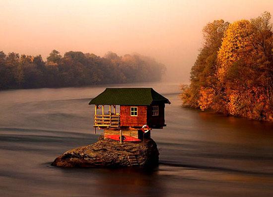
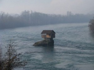
Of course, this has me thinking…. any rocks I know of, big enough for a hideout of my own? 🙂
Thank you, CBC! 🙂 Original article is here.
I thought it might be useful to take some time to explain how maps work.
The Earth is divided into sections, using lines that run North-South and lines that run East-West. The size of each section depends on the scale, such as 1:250,000 or 1:50,000. The larger the second number in that ratio, the more “zoomed out” the map is. If you think about it, 1:1 would be a life size drawing, so the bigger the ratio, the more of “real life” is represented on the piece of paper that makes up the map.
These more-or-less rectangular sections are grouped into 4 x 4 grids. Canada is divided up into large numbered sections, with numbers increasing from East to West and North to South. For example, Saskatchewan is essentially 72, 73 and 74, Alberta is 82, 83 and 84, and BC is 92, 93 and 94, with the larger number being farther north. Within each, the land is further subdivided into 16 sections (in a 4 x 4 grid) and given letters as names. Again, each lettered sections at the scale of 1:250,000 are divided into 16 maps (4 x 4 grid) that are numbered.

See how “D C B A” goes across the bottom? Letter A is in the lower right corner of section 83 in the map above — the letters zig zag their way through the grid, from A to P. The numbering within each section, 1 to 16, is in the same manner.
So, now you can see how to track down which map you need for a given area. Look at this one:

See the Peace River squiggling its way from the lower left corner to the upper right? On this map, it comes on the scene in D4 as little blue line. Suppose, however, that you want to start your trip at Notikewin Provincial Park — that’s the green blob in section F which the river flows past. You will need to get maps for 84-F (1:250,000) or for more detail, F3 and F6 (1:50,000). I can give you a tip: for the Peace River, you don’t really need the 1:50,000 scale, which is a good thing, because if you did, you’d need a LOT of maps. The 1:250,000 scale work well enough. For the Hay or Chinchaga rivers, you’ll want the 1:50,000 scale. For my own use, I open the maps in my computer and crop out the parts I don’t need and then get them printed on 11″ x 17″ paper. They work great this way!
Now, to find a specific spot on the Earth, you need coordinates. Latitude and longitude is the old way of doing it, and the numbers increase from East – West and South – North. To remember how it works for longitude (East-West coordinate), a good way to think of it is that’s the direction that the sun moves across the Earth — it rises in the Maritime provinces before it gets to the prairies. As for latitude, the higher North you go, the bigger the number. You can use degrees, seconds and minutes, or simply decimal degrees (such as 54.43532 N) for both coords.
There is another coordinate system, however. In that one, called UTM (for Universal Transverse Mercator), the East-West coordinate increase is reversed; this one gets bigger from West to East, like when you read a book from left to right. The other coordinate still gets bigger as you go North. Here, the coords actually translate into metres on the Earth, and they are called “Northing” and “Easting.”

Look at a 1:250,000 topo map like the Canadian Government makes available (a portion above). The UTM coords are indicated in light blue letters and grid lines and the Latitude/Longitude is in black along the sides of the map. Lat and Long have no grid lines spanning the map.
The multitude of orange lines everywhere are gravel roads and they delineate sections, such as farmers use. The grey fat lines (and corresponding grey letters using R and Tp) indicate townships and sometimes county boundaries, but that’s a whole other geography lesson!
So, if you had to figure out where you were, you could read your coords off a GPS and then find them on the map by seeing where the two numbers cross. You might be thinking “but my GPS display will show me where I am.” That is true, however, when you are in the wilderness, you may find your GPS unit to be surprisingly non-useful — it will show you nothing if there are no roads or labelled features in its database. Wilderness = big empty space. This, of course, is not true! Wilderness = trees, creeks, wetlands, more trees, shrubs, hills, valleys, ponds, and so on.
Of course, the beauty of topo maps is seeing the slopes (topography). This gives you heads-up as to where the highest banks along the river will be, and where creeks flow in. Just a couple other notes: green areas are undeveloped (crown land) and designated parks. White land is, essentially, land that is owned by someone (farm land around here). Blue is obviously water, and marshy areas or wetlands have little, well, marshy symbols! Black dotted lines are usually cutlines and/or seismic lines, but can also be pipelines or quad/skidoo trails.
There is an abundance of information portrayed on a map once you know how to read it! Aren’t maps great!?
For more about the National Topographic System of Canada, go here.
In the spirit of sharing, inspired by Derek Sivers, the amazing guy who started CD Baby and made it into a phenomenal success, I thought I’d share some paddling tips I’ve learned over the years. The ones below are for expeditions in particular.
Give yourself more time, not less. Whenever there’s question of how long it might take to paddle a certain stretch of a river, always plan for more time instead of less. Bring extra food. Then, if you’re using a SPOT device, your pick-up person will see you’re running a little behind and pick you up later.
You don’t need all the fancy gear. A quick-dry shirt and pants that dry fast are about all I would say you need as far as particular clothes. You don’t need expensive wool long johns — they are $100+ in some stores! — any old pair will do. Boring old rubber boots, whatever water socks or sandals you like. It’s one of the best hobbies for not needing a lot of specialized gear. I hate to say it, but MEC and similar places make you think you need to spend hundreds on clothes, but you don’t. At all. The only exception to this, I’m afraid to say, is a good quality bug jacket and hat!
Bring extra socks. When you’re cold and wet, nothing feels better than a clean, dry pair of socks. And they are so small, it’s easy to pack a few extra pairs. Along those lines, always have two pairs of footwear, such as sandals and rubber boots, or running shoes and boots. Try to keep one dry at all times, so you have can have happy, warm feet in camp.
Follow along on your maps. Always keep track of where you are. You never know when you will need to go for help. It can be tricky on bendy rivers, but you have to find a way to do it. GPS units are great too, but don’t assume yours has any good databases showing the rivers — check first. You can always use your GPS to confirm your location by looking at your current coordinates. If you don’t know how to read a map, learn (I’ll do a post on this another time)! It is also a very good idea to know the wilderness rating of the river you are going on.
Wear some type of footwear at all times. It can seem so fun and fancy-free to be barefoot in your canoe, but if something should happen and you get separated from your boat, you might need to walk out. Doing so barefoot would be a thousand times harder than even the skimpiest sandals (running shoes, even better).
Take along some fire starter. You can’t always assume there will be dry tinder readily available. Have some paper, fire starter-sticks, or whatever you find to work best and, of course, matches. If you need a fire in a hurry, this will speed things up a lot. Double bag it in ziplock bags.
Don’t forget about fresh food. For shorter trips, you’d be surprised what food will keep. Fresh cucumbers or tomatoes are so tasty! Mind you, food always tastes better when you’re on a trip. I don’t know if it’s the outdoor air, the exercise, or the river flowing by, but supper in camp is always the best. Don’t you agree? 🙂
Happy New Year! As we look back on 2012, we wanted to share some things that we’re very pleased about and some things we are looking forward to in 2013.
York Boat Expedition

Hooray for another successful York Boat expedition! Along with Jae Penner of Peace Valley Woodcraft and everyone at GeoTourism Canada, we are so pleased with how the trip went this year. Stay tuned for plans for 2013! We are working with all the partners and past crew members to formulate the best plan for offering both long and short trips on the boat. It is such an amazing experience, we are looking forward to sharing it with more people. If you are interested in being a partner, please contact us without delay!
Canoe Camps
We once again offered several successful canoe camps, including a very special one for the students of the tiny country school, Dr. Mary Jackson School. The students and principal were such a joy to work with! Thanks so much for making that canoe camp so rewarding! This canoe camp was actually “Paddle the Peace Junior” (read more about Paddle the Peace below).
Memorable Trips

The three-day trip with the Junior Forest Rangers of Sustainable Resources Development was once again, a very memorable trip. We thoroughly appreciated each young man’s positive attitude and the excellent leadership displayed by the two staff, Mike and Rob. You guys are such great examples (and also very cool)! 🙂
Paddle the Peace
We once again partnered with the County of Northern Lights, Northern Sunrise County, the Town of Peace River, GeoTourism Canada, Mighty Peace Tourist Association, the Government of Alberta and the Alberta Sport, Recreation, Parks and Wildlife Foundation to offer Paddle the Peace in Peace River, AB. Weather for the day was perfect and we all agreed that the August date worked better than the June date we had tried in 2011 (it was cancelled that year due to high water levels). Flow North offered canoe lessons for adults — which were completely sold-out — as well as helping with the safety briefing and other logistics on the day of the event. We’d really like to thank Teresa Tupper from the County of Northern Lights for all her hard work!
Presentations
Teresa was pleased to do a 1+ hour presentation at the Peace River Museum and Archives this year. She spoke about her solo paddling, sublime experiences on the river, and how surviving a thunderstorm outdoors with no shelter changed her life. Everyone in attendance thoroughly enjoyed her slides and storytelling.
Teresa and Cheryll also gave a presentation to two lively grade two classes from Florence Macdougall School in High Level. The kids loved seeing pictures of the York boat and touching the HBC coat, but I think what they remember most is the taste of bannock and dried moose meat they got to try!
In 2013…
As mentioned, we are working on the exact details of our York boat offerings for 2013. We know you need to plan in advance, so we’ll be releasing the plan soon!
We will once again be offering trip guiding to interested groups — please contact us well in advance so we can discuss where you would like to go and what we can do to make your trip extra-special.
We are still happy to offer our drop-off and pick-up service for those paddling long distances. 🙂 Making use of your vehicle is the most economical way, but even if we use ours, it’s not as expensive as you might think. Contact us for more info!
Best wishes for 2013 and beyond!
You can expect the Peace River to be running unusually high this year. You can thank BC Hydro for releasing water from the Williston Reservoir, due to higher than normal snow melt in the mountains and rainfall in BC. You can read the original press release below, and check out those numbers! Those are some serious water flows. With the river running high, be extra careful when you get in or out of your boat, make sure you camp nice and high off the water, and as always, respect the river.
Here is the latest river level chart for the Peace River at the town of Peace River.

You can check the latest river levels and other important current info on our Current Conditions page.
The following is from BC Hydro’s Press Release:
Spill scheduled at W.A.C. Bennett and Peace Canyon Dams
June 29th, 2012
June 25, 2012
Hudson’s Hope – The first prolonged release of water in a decade is scheduled to start Tuesday, June 26 from the W.A.C. Bennett Dam and Peace Canyon Dam near Hudson’s Hope. The two facilities will continue to generate power during this time.
The spill may continue, uninterrupted, until mid-August, dependent upon inflows into Williston Reservoir. BC Hydro’s Peace River facilities are designed to spill; it is considered to be a normal operation during the infrequent periods of excess inflows and water supply.
By spilling earlier, before Williston Reservoir is full, BC Hydro can release a smaller volume of water, minimizing the likelihood of a larger spill later on in the season. A spill of this size is not expected to cause flooding. Communities downstream of Peace Canyon Dam have been notified and should the spill operation change, BC Hydro will continue to keep communities informed. A similar spill was last observed in 2002.
The spill is a result of BC Hydro’s need to manage high system reservoir levels brought on by higher than average snowpacks and recent rainfall throughout the B.C. Interior. The inflow forecast for Williston is currently 125 per cent of normal for the remaining runoff season.
BC Hydro is expected to spill between 570 and 1,415 cubic metres per second (m³/s), (20,000 to 50,000 cubic feet per second) of water at both dams. Including the water used by the generating units, total discharge downstream of Peace Canyon Dam is expected to be between 2,150 and 3,000 m3/s (75,000 and 105,000 cfs). By comparison, the maximum normal discharge from Peace Canyon Dam is 1,982 m3/s.
BC Hydro may change the total downstream discharge, or end the spill without notice. For everyone’s safety, the public is reminded that they must stay well away from the spillway structures of either facility and may not stop on the W.A.C. Bennett Dam crest road to view the spill. Safe locations for public viewing of the spills are at the W.A.C. Bennett Dam Visitor Centre, or the Peace Canyon Dam Visitor Centre. Both facilities are open daily except Tuesdays through the Labour Day weekend.
Original post located at:
http://www.el.bchydro.com/mediabulletins/bulletin/system_facilities/spill_scheduled_at_wac_bennett_and_peace_canyon_dams
Another successful York Boat trip is concluded! I am so pleased to have been a part of it again this year, and once again, it was a fantastic experience. Rowing is such a nice way to travel the Peace River and sailing is even better! Pictures to come!
If you are interested in participating in a York boat trip, you’re in luck! There are still two spots available on a three-day trip in July. Although much shorter than the one we just completed, I am sure it will prove to be a once-in-a-lifetime experience. Contact Jason at GeoTourism Canada for more details. Act now to get one of those last spots!
Canoe Lessons for Adults: Flow North will be offering some adult canoe lessons through Chinchaga Adult Learning. So far, we have a full day of lessons planned for Saturday, July 28. Lessons will run from 9:30 am – 4:00 pm and cost $50 per person. Call 780-926-5625 to sign up!
Canoe Camp for Kids: In partnership with the town of High Level, we are once again offering a two-day Canoe Camp for kids aged 10 – 15. It is a day camp (kids go home at the end of the day) which takes place at Footner Lake, with all transportation provided. Contact the town at 780-926-2201 to sign your child up for this camp. There are limited spots, so call soon!
Trips this summer: Many people ask us what trips we have planned this summer! Well, we don’t operate like other outfitters – we don’t schedule a bunch of trips and then make you plan your schedule around us. If you want to go on a trip and you have a group of 4 or more people, give us a call and we’ll talk about what you have in mind! If you have a group that is interested in just going for a day, you can also have a Canoe Party.
The York boat expedition for 2012 is underway! Flow North is not as fully-involved as last year, but we are still very excited to see the boat in the water. GeoTourism Canada is recreating the expedition we did last year, from Fort Dunvegan to Fort Vermilion, on the Peace River. And I, Teresa (Flow North’s owner/operator) will be on it!
Because of a canoe camp we did for the Dr. Mary Jackson School from Keg River a few days ago, I couldn’t do the whole trip, but I am joining them at Notikewin Provincial Park for the second half of the trip.
This is a wonderful, unique boat! So, if you would like to come see it and chat with the crew, here are your options:
– Notikewin Provincial Park today (June 8) or tomorrow (June 9) morning
– Tompkins Landing/La Crete Ferry Campground on Monday, June 11 (aprx 3 pm on)
– Wall’s Landing on June 12, afternoon/evening (ask someone from LaCrete for directions)
– Fort Vermilion on Friday, June 15, afternoon
Sorry we can’t give more exact times for our arrivals, but it’s hard to say exactly when we will arrive and I hate to promise something we can’t deliver on.
Hope to see you there!
Note: Contact us if you are interested in having a Canoe camp (2 days of canoe lessons) for a group you lead. We are also doing some adult canoe education, open to the public: Sat, July 28 near High Level and Sat, Aug 18 in conjunction with Paddle the Peace in Peace River, AB.

Teresa was the faithful captain of the trip. She started out as manager of the project and graduated to captain. She was able to keep the crew in line (which was easy) and got to make all the big decisions (which was hard).