Peace River | Hay River | Chinchaga River | Wabasca River | Hay-Zama Lake | Rainbow Lake | Hutch Lake | Footner Lake
The Peace River [Map]

The Peace River is a big, historic river. In the early days of Canada, it was the main mode of transportation used by explorers, the Hudson’s Bay company, and originally, the First Nations people. It gets its name from the peace treaty in 1719 that ended hostilities between two tribes: the Beaver (or Dene, pronounced “den-ay”) people and the Cree. The treaty of Peace Point, made possible by a Cree trader named Swan (or Wapasoo), stated that the Beaver would stay north of the river and the Cree south, which is as it is today.
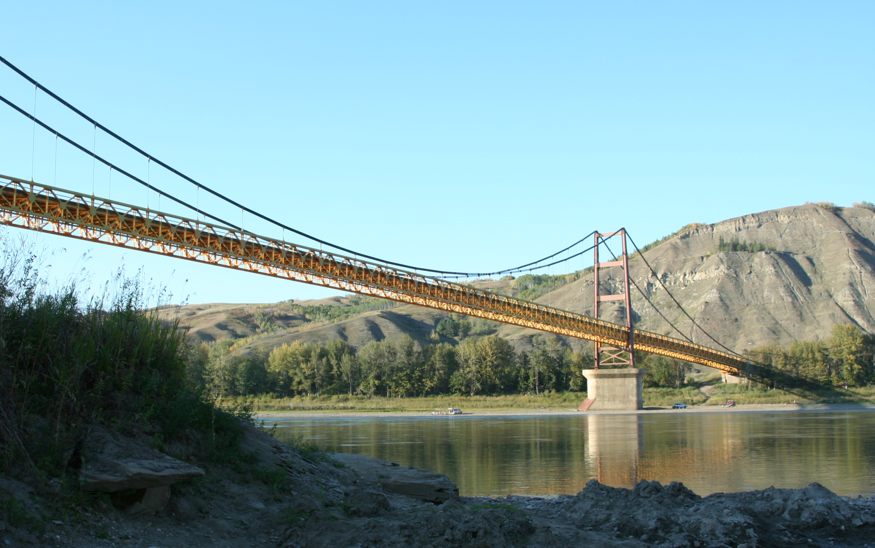
The Peace River was the “freeway” to Fort Vermilion, Alberta’s oldest settlement. Its headwaters are in northern British Columbia. There are two hydroelectric dams near Hudson’s Hope, BC, the larger of which creates Williston Lake, the largest man-made lake in the world, and up to 2,730 megawatts of electricity. From the second dam, the Peace River flows roughly eastward towards Dunvegan, which was a fur trading fort established in 1805, and which now has a historic site, campground, and
Alberta’s only suspension bridge. The river continues east to the town of Peace River before turning northward, and then eastward again to Fort Vermilion. The Smoky and Little Smoky rivers join with it, as well as the Heart, Notikewin, Wabasca, and a million smaller rivers and creeks. It flows into the Slave River near Lake Athabasca, which spans the Alberta/Saskatchewan border.
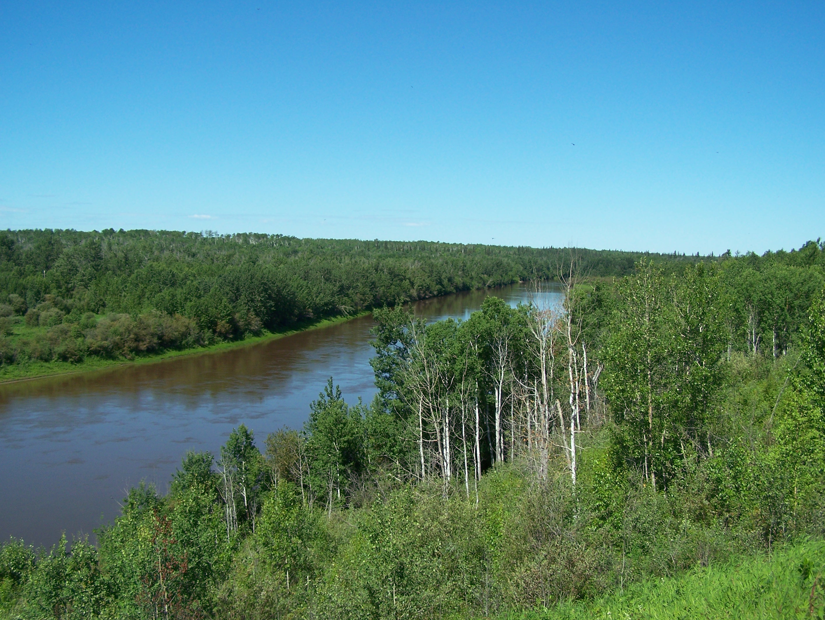
It is wide and generally flat, except for the Vermilion Chutes, a 4-5 metre drop located about 75 km downstream of Fort Vermilion. Under no circumstances should the chutes be attempted; a well-marked portage trail is found on the south side of the river, and paddlers must take care to follow the south shore to ensure they can reach the portage safely. This Parks Canada page gives great detail about the portion of the Peace River from Fort Vermilion to Peace Point, in Wood Buffalo National Park. Wood Buffalo is the largest National Park in Canada, with an area a little larger than Switzerland. It is home to hundreds of free-roaming wood buffalo, and nesting grounds for many species of birds, including the Whooping Crane, Peregrine Falcon, and many other shore birds, cranes, eagles and hawks.
It’s about 1920 km long, and ranges from 1 to 1.8 km wide. The slope is generally less than 1m per km, and the flow rate varies from 2 – 7 km/h depending on the time of year and amount of runoff. This river can be paddled into September, with sand bars and beaches growing, but still plenty of room to maneuver around them. Fossils have been found along the shores, as well as evidence of petrified forests.
If you’re interested in paddling the Peace River, call us and we can talk about what section you’d like to do. There are several spots where one can put in for a day trip or you can take a 30 day expedition!
Visit this page from the British Columbia Ministry of the Environment for more information, including info about fish species.
For more information on the Peace Point treaty, read the “Heritage Trails” transcripts: Part 1, Part 2, Part 3, Part 4.
The Hay River [Map]
Much narrower than the Peace, the Hay winds its way through Northwestern Alberta, starting southeast of Rainbow Lake (the body of water, not the town), which is actually just a widening of the Hay River. It makes its wandering way west, into British Columbia, then curves northward, then eastward until it reaches the Hay-Zama Lake wetlands area. It flows through the wetlands as a river flowing through a lake — depending on the water level, the Hay will have a shallow bank or the bank may be submerged. Thousands of birds (ducks, geese, cranes, etc.) use this wetland and the skies come alive during migration. This led to the creation of the Hay-Zama Lakes Wildland Park which was declared a Ramsar Wetland of International Importance. There is a healthy herd of free-roaming Wood Bison that live near the Park (and the Assumption/Chateh First Nation reserve), and if you’re lucky, you’ll get to see them. There are hundreds of hoof prints along the lake shore. From the park, the Hay River continues flowing east, where after 58 km of many meanders, the Chinchaga River joins it.
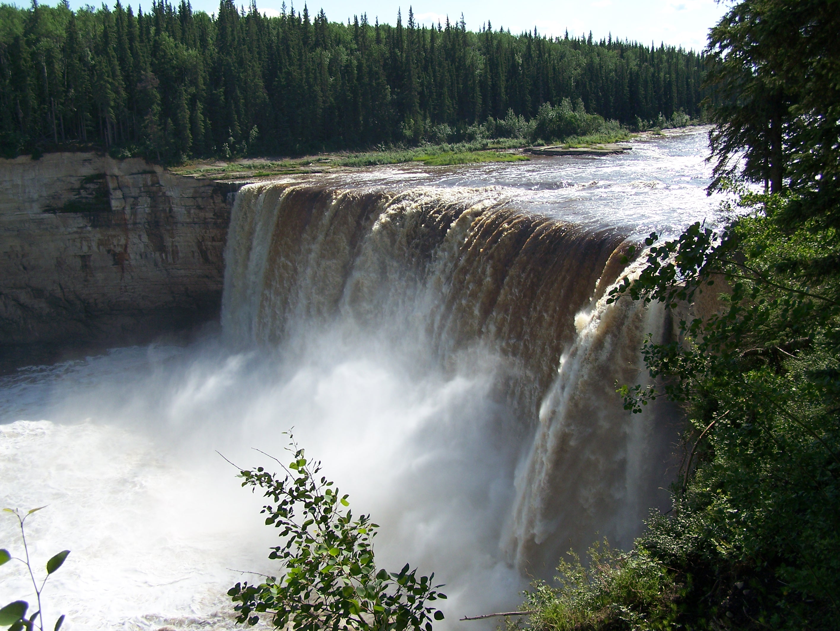
Another 91 km downstream, it joins with the Meander River and turns to flow north. From here, the Mackenzie Highway roughly follows the river, which means it is somewhat less remote than many of the other waters we paddle. It flows north all the way to the Great Slave Lake, but not before going over two escarpments in spectacular falls, the Alexandra Falls and Louise Falls, both in the Northwest Territories. Neither of these falls should ever be attempted in any boat – to do so would be stunting akin to going over Niagara Falls in a barrel! And every bit as dangerous!
The Hay River was also used as a fur trading route, and there are buildings from the 1800’s at Indian Cabins, a highway stop a mere 15 km south of the Northwest Territories border. The Hay can be paddled all the way to the border, where the 60th Parallel Campground is a good spot to stop.
There are many opportunities for short or long trips on the Hay. It would take around 7-10 days to paddle the entire thing, but day paddles near High Level are also possible.
The Chinchaga River [Map]
The Backroads Mapbook has this to say about the Chinchaga River (in the “Paddling” section at the back):
“This long, meandering river has rarely been run, and information is scarce. Low water limits the time it can be paddled (think early spring) and lack of information tends to keep people away from this wilderness river. There are two sections that can be paddled. From a bridge over the Chinchaga, just north of Keg River to the Highway 58 bridge is a long class II/III wilderness paddle that will take upwards of a week to do. There is a little park at the Highway 58 bridge where people like to float downstream for a kilometer or so, and then hike back up to the bridge.”
This is mostly true, although there are more than simply two sections. One can paddle the whole river, as suggested, or put in at the Highway 58 bridge and paddle to connect with the Hay River, a section filled with many meanders. You should not be in any kind of hurry and paddle the Chinchaga River! Check out this Google Earth kmz file to see the many oxbow lakes, caused by meanders in the river that are cut off from the flow over time. Farther upstream, there are some amazing cliffs along the river. Although this river is remote, there is quite a bit of forestry activity along it, and one can see clearings (forestry cut-blocks) beyond the trees that line the river. The name “chinchaga” means “big wood river” or “big timber river,” because of the large spruce trees along its banks.
The Chinchaga is a much narrower river than the Hay or Peace, which makes it a fun one to paddle! It’s also fairly shallow, and should be paddled in spring or after lots of rainfall. The water level is monitored by Alberta Environment, and we check it frequently. At high levels, the “Chin” River can give a drift-rate of 5-7 km/h. At low levels, the river can be more like a trickle in a gravel bed!
The Chinchaga Wildlands Park is located in western Alberta, along the south shore of the river, near its headwaters. It is home to grizzly bears and woodland caribou, and a nesting ground for trumpeter swans. The park covers 803 square km, but is not easily accessible by road. In fact, many roads in this part of Alberta can barely be called “roads” — they are wet, soft, muddy, uneven trails of ruts going through the bush!
The Wabasca River [Map]

The name of this small river comes from the Cree word for “grassy narrows.” It starts at the North Wabasca Lake, about 90 km northeast of Lesser Slave Lake, and a mere 450 km downstream, you’re joining the Peace River. The full length of the river from the lake to its confluence with the Peace can be broken down into shorter trips using highway crossings as put-ins or take-outs. Highway 88, a gravel highway, follows it somewhat for the latter section. The Wabasca is similar in scale to the Chinchaga, and is very meandering in the northern sections, and less so in the southern part.
The whole river can be paddled in a minimum of 8 days, but can take significantly longer than that — even double — depending on the water levels. In fact, the water levels will vastly affect the paddling experience on this river, as it is rated class I-III, and the bigger rapids may require lining around, or portaging. At low levels, exposed boulders will cause you problems, and inexperienced paddlers should think twice about choosing this river. The section north of the Tall Cree Bridge is the easiest, with the least rapids, and can be paddled in 2-3 days.
Hay-Zama Lake [Map]
 The air was smoky due to forest fires.[/caption]
As mentioned in the Hay River description above, the Hay-Zama Lake is at the centre of the Hay-Zama Lakes Wildland Park, a protected area due to its significance as a unique wetland habitat. Hundreds of thousands of migrating birds use this area, including Sandhill Cranes, Canadian Geese, Lesser Snow Geese, Golden Eagles and many other species. Ducks, gulls, terns, raptors, including Bald Eagles, and Great Horned Owls, to name a few species, nest in the park. There are approximately 500 Wood Bison living along its shores and in the area, re-introduced to the Hay-Zama Lakes from Elk Island National Park in 1984. This herd is independent of those in Wood Buffalo National Park.
 See the herd of Buffalo in the distance?[/caption]
These bison roam in large herds near the lake, Assumption/Chateh native reserve, and roads nearby. They are huge and impressive animals, and the sight of seeing 30 of them on the road in front of you, or 50 on the open prairie is one you’ll never forget!
The shores, and the shape, of this wetland change depending on the water level. Due to its size, the wind can stir up some large waves, so it’s best to keep a close eye on the weather if you plan on paddling unprotected areas.
Read the Alberta Wilderness Association page, the Environment Canada page, or this pdf (1MB) for more information about this unique area. [B & W map]
![[B & W map]](http://flownorth.ca/wp-content/uploads/2009/10/HAYZAMA-map.jpg)
Rainbow Lake [Map]

Rainbow Lake is a natural widening in the Hay River, far upstream of where the Hay flows through Hay-Zama Lake. The lake itself is about 40 km from the town of Rainbow Lake, on a gravel road used mostly by the various rigs and gas plants in the area. Four wheel drive is not required, but a high clearance vehicle is. Drive it at your own risk after a lot of rain — be prepared for huge mud and 4WD on some sections. There is a 19-site campground with a small playground, and several “tents only” sites along the lake shore. Basic outhouses, fire pits, and firewood are the only other services.
The lake is long and slim, a lovely hidden paradise in the wilds of Northern Alberta. At 13 km long and less than 500 m wide at its widest point, it’s great for canoe day trips. Walleye and northern pike are commonly fished in this lake, with some record-makers pulled out every year.
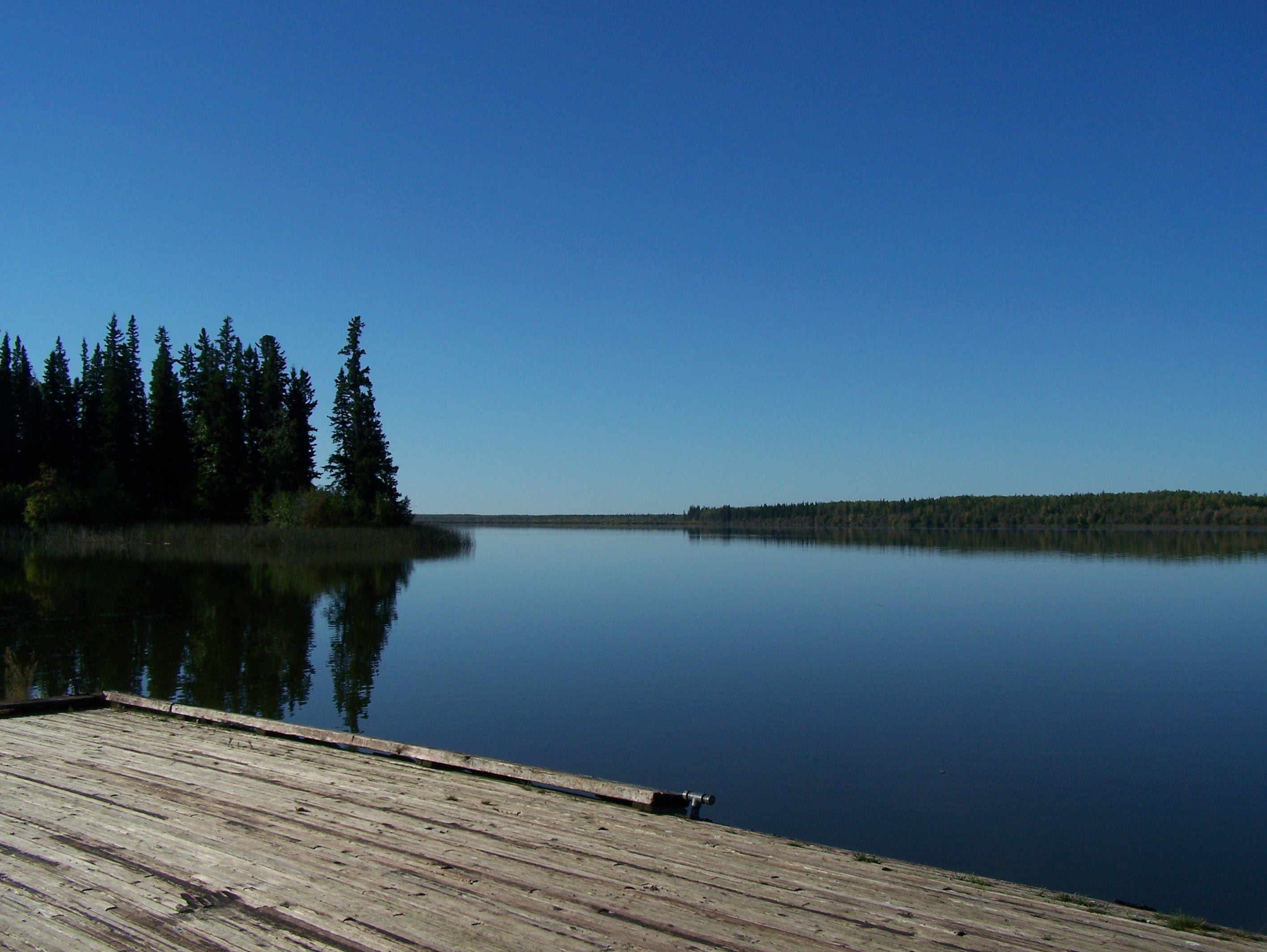
Hutch Lake [Map]

Hutch Lake is a man-made lake about 30 km north of the town of High Level. It was created by building a dam/weir at its north end, and the resulting reservoir is Hutch Lake. The overflow trickles northward and eventually becomes the Meander River, which joins the Hay River at the First Nations community of Meander River. Hutch and Footner Lakes are somewhat related; both lie in a long, slight valley and marshy area, with Hutch Lake situated north of Footner, in the shadow of Watt Mountain.
There is a recreation area at the north end of Hutch Lake, accessible by road from Highway 35. This is essentially the only spot to put-in or take-out; the only other lake access is at Hutch Lake Cottage Area (privately-owned residential lots). The rec area has a small beach, boat launch, and dock, so any combination of these can be used to launch your boat. The dock is a bit high for kayaks, but works for canoes. The rec area also has a campground, picnic area, and outhouses.
Hutch Lake is the shape of a bent cigar, relatively long and narrow, so depending on the wind direction, it can build up some waves. Its size and location make it a great spot for day-trips close to High Level! There are wild raspberries and saskatoons along the shore. On a paddle at Hutch, you’re likely to see many ducks, gulls and sandpipers, and if you’re lucky, Lynx.
Full Moon Paddling will take place, weather permitting, at Hutch Lake. You can also have your canoe party at this lake!
Footner Lake [Map]
Footner Lake is located about 10 km north of the town of High Level. It is right beside the airport, and the lake has a water aerodrome. The airport was originally built beside the lake in order to create a forest fire fighting base; the lake provides a water source for fire-fighting aircraft such as CL-215’s to fill up by scooping water from the lake. There is a small gravel boat launch and large, solid dock, built for use by float planes. In fact, when crossing the lake, it’s always a good idea to keep an eye out for planes lining up to land, just in case! Float planes are only spotted here from time to time in summer, but you’ll see or hear other small aircraft and helicopters making use of the airport.
It’s not a very big lake, only 1 km wide by 4 km long, but it makes for a nice morning or afternoon paddle. We’ve gone exploring in the reeds along the north and south parts of the lake, paddled right beside a beaver lodge and surprised many ducks.
Footner Lake is the location for Family Canoe Night, as well as activities such as canoe camps and Try a Kayak Day. You can have a canoe party here, too.
Compare Lakes and Rivers
Peace River | Hay River | Chinchaga River | Wabasca River | Hay-Zama Lake | Rainbow Lake | Hutch Lake | Footner Lake