Even though it’s fluctuating between -20 and -30 C, we’re still thinking of paddling! We’re in the works planning some themed trips, which we’ll announce soon, and we’re also performing a survey to see what people like best in a paddling trip! We’re looking for as much feedback as possible, so please visit the link below to do the survey!
I am unveiling two presentations about my paddling experiences this summer. If you know of an event looking for a speaker, please have the organizer contact me. I am happy to adapt either presentation to suit the audience and/or make it shorter or longer as needed.
800 Kilometers on the River — Insights from my Summer of Wilderness Paddling
30-minute presentation
Join outdoor enthusiast and owner of Flow North Paddling Company, Teresa Griffith as she shares the challenges and triumphs of canoeing and kayaking over 800 km on the beautiful Peace River. In total, she paddled for nineteen days — ten days solo, nine days with a canoe partner — steeped in the beauty of the wilderness river. She overcame shoulder trouble, thunderstorms, shallow water, strong wind and waves throughout her journey. She spent seven continuous days alone on the water, with only herself and her kayak, and she wasn’t the same when she finished. She shares inspiration which came to her on that portion of the trip, when time stood still and every paddle stroke was a meditation.
800 Kilometers on the River — Lessons in Independence
50-minute presentation
Join outdoor enthusiast and owner of Flow North Paddling Company, Teresa Griffith as she shares the challenges and triumphs of canoeing and kayaking over 800 km on the beautiful Peace River. In total, she paddled for nineteen days — ten days solo, nine days with a canoe partner — steeped in the beauty of the wilderness river. She overcame shoulder trouble, thunderstorms, shallow water, strong wind and waves throughout her journey. She spent seven continuous days alone on the water, with only herself and her kayak, and she wasn’t the same when she finished.
A dynamic speaker, Teresa gives an outline of her past experiences which led her to make this journey. She reviews her trip preparation and practical aspects of the journey. She also shares inspiration and insight which came to her on the solo portion of the trip, when time stood still and every paddle stroke was a meditation. Sitting out a severe thunderstorm on the river’s muddy bank, nowhere to hide, wisdom and poetry surfaced from somewhere deep within. You’ll be encouraged, uplifted, and inspired to stretch yourself beyond what you thought possible.

Now that mosquito season is over, we can laugh about it, right? It wasn’t soooo bad… well, except that one time! 🙂 And of course they’re never as bad when you’re on the water compared to in the bush!
Yes, we have mosquitoes in Northern Alberta… many, many mosquitoes. I came across some neat facts today about them in Social Studies: The Best of the Globe and Mail’s Daily Miscellany of Information. My comments are in italics.
– “Mosquito” is Spanish for gnat and originally applied to many small species of bloodsuckers.
– Worldwide, there are about 3,400 species of mosquitoes. Canada has at least 77 species. The tropics have the most varieties, but the father north you go, the greater the number of individual skeeters. Northern mosquitoes buzz louder, land harder and itch more. I knew it!
– Canadian researchers in the Arctic have reported a rate of 9,000 bites a minute. That would drain a person’s blood in two hours. For the record, in all my life, I’ve never experienced 9,000 bites a minute! Not even close… that is crazy! And who would ever sign up to be the bait for that experiment!
– It is the females who bite, to get sustenance for their eggs. Male mosquitoes feed entirely on plant juices. Activity peaks at dawn and dusk. It takes 90 seconds for a biter to become fully gorged. A well-fed female can fly carrying twice her normal weight in blood.
– Hungry mosquitoes will attack a warm billiard ball, but they prefer people. They are attracted by carbon dioxide, lactic acid, moisture, and warmth; nervous, fidgety people are twice as likely to be bitten as calm individuals. Stay calm! Mosquitoes are twice as attracted to blue as any other colour, and have a yen for people who eat bananas. Accumulated sweat is also a turn-on. And it isn’t for your fellow-paddlers! Although you may be tempted to throw hygiene to the wind, don’t let yourself get too stinky or you’ll regret it!
– Some species prefer to attack birds or reptiles. Charles Hogue, an entomologist at the University of Southern California, has said that only 10 percent of the world’s species are interested in biting humans and far less than that carry diseases.
– A mosquito bite begins to itch after about three minutes. This allergic reaction can diminish over the spring and summer as a person develops a tolerance; the bumps will be smaller and won’t hurt as much. However, moving to a new region and being bitten by a different species means building a tolerance all over again.
There are a few other points that I know personally. The first ones of the year, in May, are slow and stupid. The later generations (or species) to hatch are much faster and hungrier — positively fierce! When you’re far enough north, there’s no getting away from the bugs — mosquitoes use standing water to lay their eggs in, and blackflies use moving water. So, mosquitoes don’t tend to be as bad along a river, unless there are sloughs or ponds around as well. Blackflies are more abundant farther north, along the Mackenzie River in the Northwest Territories, for example.
Bats are voracious mosquito-eaters, consuming a few hundred in flight in one night. Dragonflies will eat them as well, which makes them my favourite insect.
So what if they outnumber humans 1,000,000 to 1! Let me share my best defenses:
– A bug jacket or hat. When it’s warm, the jacket is great because then you don’t need to wear layers. The bug hat saved my sanity one evening on the Peace River. I just couldn’t swat them as fast as they landed, and do anything else with my hands, like putting things away for the night. So, I put on the bug hat, sprayed bug dope on my hands, and went about my work. Which leads me to…

– Mosquito repellent. Bug dope. Whatever you want to call it, it is definitely helpful at keeping the skeeters off you. The problem is, it’s a pretty nasty chemical, which is why there are warnings on the bottle. Don’t put on skin under clothing. Don’t reapply too many times. Don’t put it on young children. One warning they don’t include: Don’t spray your hands and then wipe your eyes! Yeow! In the photo above, number 4 has the highest deet, but number 1 or 5 will also work, and number 2 to a lesser degree.
– Organic bug spray, Orega Spray, made of oil of oregano, clove, wild lavender and wild bay leaf, is a great option if you’d like to stay away from the pesticides (number 3 in the photo). I wouldn’t use it in the bush, but I tested it in our back yard, it was quite effective. It would probably be effective in the bush, but since it makes you smell like an Italian restaurant, that might attract bears. I’m pretty sure they like Italian! Oh, did I mention that it’s expensive? Essential oils aren’t cheap!
– Antihistamines. If you get very itchy from mosquito bites, you can reduce your allergic response by taking antihistamines in advance. Vitamin C is a natural antihistamine, so you can try 2,000 – 4,000 mg per day. You will pee out the extra vitamin C that your body doesn’t need, but if you are having an allergic response, your body will use it!
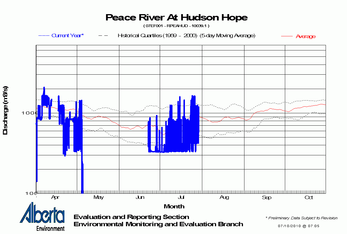
I thought I’d take a minute to explain how to read the river graphs that Alberta Environment produces, and take a look at the difference between a dam-controlled river and a natural one.
Let’s start by looking at a natural river, the Hay River. The blue line is this year’s measurements, and the historical values are indicated by the dotted lines, with the fine red line being the historical average:

Look at the historical values. You can see the peak of spring run-off quite clearly, and the whole graph has a certain “downhill slant,” doesn’t it? Now, let’s try the Chinchaga, another natural river:

Again, there seems to be a peak showing spring run-off, with a gradual decrease throughout the year. The blue line almost looks like handwriting, written with a left-leaning slant. This is the way it should look — rain showers cause peaks and then the water flow gradually decreases.
Now let’s look at the Peace River, controlled by two dams (but really, just the second one, the Peace Canyon Dam). Hudson’s Hope, the monitoring station closest to the dam, looks like this:

The first big difference you’ll notice is the blue line, the annual data (this one is from last year, because this year’s graph has a lot of gaps in it). It goes up and down like crazy, doesn’t it? Well, that’s exactly what the water level near Hudson’s Hope does. The dam HUGELY affects the amount of water flowing downstream, and when it releases extra water due to additional electricity demand, it shows. The water level can easily go up 3 or 4 feet overnight (or in any short period). Some of those variations are 420-1050 cubic metres of water per second — 2.5 times the volume (for example, from August 2-5)! This graph is on a logarithmic (log) scale, so notice how the lines are closer together below 1000, which can make the variation appear smaller. Log graphs are used when there is a large variation in the data being displayed (no kidding).
But let’s not forget to look at the historical figures. They don’t look quite right, do they? There is no peak spring run-off — instead, the water level decreases when it is supposed to increase (May-June). We don’t even see a peak for all that snow in the mountains melting! That’s because it’s all captured in Williston Reservoir and held back for controlled release by the dams. This confirms what I noticed while paddling. The shores didn’t look as they should. They don’t have a gradual muddy cliff-bank, with lots of horizontal layering. Compare these two photos:
 [/caption]
Shores near Taylor, not showing muddy bank or layering along shore
Let’s look a few more graphs for the Peace River. Here’s Taylor, BC, almost 100 km downstream:

Still a lot of unnatural variation in the annual data, but is that a small peak I see near the beginning of June? Perhaps; the water level is now affected by the dams PLUS a couple of rivers, the Halfway River and the Pine (depending on exactly where the monitoring station is — I don’t remember seeing it). Let’s go a little farther, to the town of Peace River (375 km downstream):

Looks similar to the Taylor graph, doesn’t it? Except now the blue line has less-radical variations — the river has had some time to even out the effect of those huge water releases. Also notice that the overall volume has gone up quite a bit — above 1000 — whereas at Hudson’s Hope, it was generally below 1000. That’s because several rivers and a hundred creeks have added their water to the Peace by now. But, still no spring run-off peak in the historical data.
Let’s look at one more, the farthest point that is monitored, Peace Point, approx 1115 km downstream of Hudson’s Hope:

This is the closest the Peace River comes to looking like a natural river, and the shape of the historical curve still isn’t right. It’s interesting to note that the data used for the historical quantities starts in 1967, one year before the Bennett dam opened. I guess they thought they should monitor the river level, which is good in terms of trying to understand the effects of the dam(s), but they didn’t start enough years ahead to get a pre-dam historical baseline, to see what the spring runoff was really like. Many environmentalists believe that the Peace-Athabasca delta, a Ramsar site of International importance, is suffering because without that mighty inflow of water once a year, some areas of the delta do not receive the water they need. If we extrapolated what the Hay River spring run-off peak looks like and imagined it on the Peace River graph, it would reach discharge levels of almost 10,000 (at least 8,000, I’d estimate).
I know there is some debate about how the dams affect the Peace-Athabasca Delta, and if you read the wikipedia page, it doesn’t sound like there’s any problem. Just remember what wikipedia is: an open document. Anyone can edit what he/she sees there. It can be slanted by opinion and altered by those with an agenda. I’m not saying it isn’t great! Just that it isn’t always, necessarily, 100% true.
Well, with the beginning of October, paddling season is officially over. However, we are enjoying a very nice Indian Summer, so if it’s particularly nice one day and you really want to go for a paddle, you can still give us a call. Until the ice starts forming! Then we all have to wait for spring!
Even once it’s too cold for paddling and all the water is frozen over, keep checking this blog throughout the winter. I have lots of ideas for blog articles that I’ll be writing up into posts. I’m also working on getting an RSS feed going and a really nice gallery of all the pictures I’ve taken! So stay tuned! And also make sure to check out this new page with comparisons of our local rivers and lakes to get you thinking about next year!

Cliffs along the Peace River
Well, I took Saturday, Sunday and Monday to finish the big trip on the Peace River I started in July, from Peace River (the town) to Fort Vermilion. I started at Tompkins landing, just a few metres from where I had finished about 5 weeks before. One major difference this time was that I didn’t have to dodge (or be aware of the comings and goings of) the ferry. The water level is so low, the ferry is anchored on the east side and not running at all. This means that all vehicle traffic has to drive to La Crete and Fort Vermilion the long way, through High Level. I definitely noticed the increased road traffic across the Vermilion bridge… but I’m getting ahead of myself.

The trip went really well! It’s about 136 km, and I didn’t push myself the first day, going only 34 km. Remember, my goal in the original trip was 50 km/day, which I held to, which would have meant a slightly shorter leg of only 43 km on the third day. This isn’t how it went, though! I did 34 on the first day, as I said, 49 on the second day, and 53 on the third. Whew!
I had nice weather on all days, and generally felt like I was really picking up from where I’d left off. Except that it was a bit cooler now. I had almost all the same equipment, except I added a collapsible bucket but forgot to bring a facecloth or towel, which meant I didn’t really need the bucket! I really missed the facecloth and towel, and I’m not sure how I forgot them. I was a little less strict about my list, since much of the stuff was still packed in dry bags and simply had to be reclosed. Obviously I had to pack clothes again, and I brought a few more items — a wool sweater for example, which I wore on the morning of the third day. I hadn’t packed warm gloves, which I also wished for, since it was a little breezy and cool on the evening of the second day.
I found some really unique spots to camp this time, so I was very happy about that. The first night, for example, I camped beside a dirt-quad trail, thinking it probably never got used. Nope. I had 5 horses and one quad pass by me, twice. Once on the way down to the water and again on the way back. I thought I might get trampled by one horse who was very skittish. It seemed she could smell me, but since I was in my tent (I went to bed early that night), she couldn’t see me, and instead only saw an odd blue cube (what would a tent look like to a horse?)! So I popped my head out and said “hi” but this didn’t calm her much! Now I was a disembodied head sticking out of an odd blue cube!
I knew this trip would be less remote than other sections I’d done, but this was more company that I’d expected!
The second night I had no visitors at all, as I was much farther from any roads or trails. I took a chance down a narrow channel between an island and the shore and found a great little spot, albeit a bit lacking in wind protection. I learned patience while I sat and held up a thick drybag as a windbreak for the cookstove — and yes, a watched pot will eventually boil! Supper was very tasty that night, perhaps because I was a little more tired. As I breezed by Atlas Landing on the second day, I think the people fishing and relaxing there must have wondered about me… I didn’t stop, just came very close, took a GPS point, said “hi…. yes, I’m on my way to Fort… I’ll arrive tomorrow. Have a nice day!”
The third day was the toughie. Not just because it was the farthest, and not even the slowest current, but somehow it was the toughest. I think my body was getting very tired and I was fighting a cold. I ate a Mars bar for energy at one point and immediately felt my throat get sore — not a good sign! I tried to stay hydrated, but I think I got a little dehydrated too. You really have to be very careful about this! Although I found Gatorade helpful in the first part of my trip, I think the sugar wasn’t helping my impending sore throat. I have found that sugary and fizzy drinks give me a sore throat even when I’m not overdoing it by paddling 53 km in one day! I was also surprised by how tired I was since I even paddled 60 km one day on the first trip (mind you, I was pretty toast after that).
The scenery along this reach is lovely as always. Many of the islands show more erosion than deposition, which was interesting. They had steep cliffs showing layers instead of the long, gradual slopes. The water level was so low, there were sand bars showing — really, it was the river bed — beside some of these steep cliffs. It was weird to see! I mean, a long, gradual slope just shows more when the water is low! But when it’s a cliff, it makes an “L” shape, and you can see the base of the “L!” So besides discovering all the shallow spots, sand bars, and gravel bars, I even got to see the actual river bed.

The BEST part about paddling at this time of year is the birds! I saw — no exaggerating — over 1000 sandhill cranes fly over me, and about 200 Canada geese migrating. I scared no less than 1000 Canada geese on the shores near Blumenort, but they didn’t start migrating. They just made a big ruckus, honking away, then flew around in circles or flew a little ways behind me and settled back again on the beach. I guess they weren’t quite ready for their Big Trip. 🙂 Overall, I bet I scared 2000 geese from along the shores (even though I never got very close)! By the way, the photo at left is Sandhill cranes, who fly very high and make wonderful “cooo cooo” noises that sound like they are gargling at the same time. Sometimes you can only hear them and can’t find them, they’re so high and so small. They’re very large birds, and quite a sight to see in large numbers! A friend and I saw a few hundred in a field about 2 weeks ago, and that was amazing too!
At long last, I saw the bridge that crosses the river, a lovely sight indeed. And truck after truck crossing it (remember, the ferry’s not running). I hope more than a few drivers looked out their windows, saw me and thought “man, that looks relaxing! I need a vacation!” I like to work hard, but I’m very much in favour of vacations! Perhaps instead they thought “geez, that person looks tired! She’s hardly paddling at all!” Um, ya, well, you would be too! I got a little extra wind (so to speak) after the bridge and paddled the glassy water to the welcome sign. How many villages do you know that have a welcome sign on their river? Then just a couple more km to the dock and I was done!
That’s all to report for now! I am still planning on doing the upstream reach of the Peace, from Hudson’s Hope (or thereabouts) to the town of Peace River. That’s about 375 km, which I was going to do in 7 days, but I might stretch it out a bit. The days are getting noticeably shorter (the sun sets at 9:15 pm now) and I think I’d like to try a more moderate pace of 30 km/day, with more time for exploring and campfire building! So, that’ll add up to about 805 km on the Peace — not quite half its length, actually. In case you think I’m
a) crazy,
b) nuts, or
c) bonkers
let me explain that I’m not just doing this to
a) be able to brag about how far I went this summer on my arms (the geese have me beat!), or
b) to have the most incredible core muscles ever (you should see me twist)!
I actually have really good reasons! They are
a) to have first-hand knowledge of the river so that when you rent a boat from us, we can really tell you what to expect, where you might like to camp, and some neat spots to explore, and
b) to write a Paddling the Peace guide for GeoTourism Canada (which you’ll all be able to download for free next spring), and
c) to write another book about all that I’ve learned on these long solo trips. Find out more about my first book here.
So there you have it. I am not nuts. I eat nuts. Then again, you are what you eat… 😉

Canada Geese

rescued dragonfly

Shadows on shore

I always blink for photos!

Fort V Bridge
I’ve been listening to my audio notes from my Peace River expedition from a few weeks ago, and it reminded me of the awesome serenity I experienced while out there on my own in the wilderness. So I’ve decided to have a 3-day “Spirit Paddle” on the Peace River, from Friday, Sept 3 to Sunday, Sept 5 (allowing everyone time to travel home on Labour Day Monday).
It’s no coincidence that the trip will be on the Peace River. It’s such a beautiful river to paddle. We’ll start in the town of Peace River and paddle to Sunny Valley, about 90 km downstream. We’ll paddle about 30 km (19 miles) each day, which is more than just floating, but not a strenuous day’s paddle. Expect to see plenty of wildlife, such as deer, moose, elk, beavers, eagles, and many other types of birds. There are bears and wolves in this area as well, but there is less chance of seeing any of them.
There is spectacular scenery along this part of the Peace River (all of it, actually)! The river has carved a path for itself out of the shale and sandstone, creating spectacular cliffs and revealing fossils. We’ll stop in a few spots to do a little rockhounding along the shore. We’ll see oil and gas exploration sites, including a patch of dead forest where an abandoned well once burned for many years! The valley is beautiful and although we might see a few motorboats and cottages, we’ll be quite alone. There are more remote sections of the Peace, but my intuition said to paddle this section.
The website with more details is here! Please use the contact us form to express your interest or ask any questions you may have.

Welcome to High Level, Little League Teams!
High Level is happy to be hosting the Little League Prairie Championship Tournament! Coaches, you will be given packages of information about the special Canoe Parties we are offering to you and your teams at the coaches meeting Wednesday morning. If you have any questions, please call us at 780-926-2649, and if you have a special request, such as a shorter or longer paddling time, a special start time, or any other change to the canoe party package. We are very flexible and we don’t mind short-notice requests!
Canoe and kayaks are also available for rent to accompanying adults — just call us and we’ll get you set up!
Looking forward to seeing you at the lake!
Mother Nature just doesn’t always cooperate with our plans, does she?!? Unfortunately, we will have to cancel the Full Moon Paddling event tonight, as the weather is still just too hit-and-miss for clouds, wind and rain. We had a canoe party today despite the weather, and it went quite well although we did get rained on a little. For the night time paddling, with all this cloud, we just won’t have enough light to paddle by without twilight and moonlight. Not to mention that it’s always cooler in the evening anyway.
So, we’ll have to wait til next month! Tuesday night, August 24 is the next scheduled Full Moon Paddling Night. If you are interested in paddling another evening, just call us!
Some of you have been following Teresa’s progress on her solo kayak expedition from Peace River to Fort Vermilion (especially using the map). I am happy to report that she is doing great.
Teresa has been averaging 46 km per day, which was her goal, and she has been on the water for 6 days and 5 nights. (Today is the sixth day.) She made her fifth camp just before Carcajou, and though I thought she would be reaching Tompkins Landing by this evening, she appears to have had a slow day today, going half as far as previous days. I will be able to catch up with her at Tompkins tomorrow, then, by driving down to meet her.
Regarding her trip, today I received a wonderful phone call from a helicopter friend of ours. He had been in Peace River this week, so yesterday, as he headed back north to High Level, he swung over the Peace River estimating where he thought Teresa would be. Sure enough, he found her. He put down on a gravel beach and was able to chat with her for a minute. He said he had no food on board, but he was able to give her some nice, cool juice boxes. 🙂
It sure is nice to have friends in high places! And I appreciated hearing that she was doing well.