Northern Canada offers many unique experiences. In case you were wondering what makes this part of our beautiful, blue marble-planet unique, read on!
Liquid Light
Imagine sitting under a pristine sky, without even a trace of artificial lighting. Stars twinkle overhead, and as your eyes adjust, you realize you can see the Milky Way. And then it starts — a green rippling ribbon of light — the aurora borealis.
There’s no way to predict for sure when it will appear, and that adds to its specialness. This website lists the KP index, a measure of solar activity, which directly affects the strength of the aurora. The larger the index, the greater the chance of seeing the aurora. There’s always aurora somewhere, but the size and intensity of the auroral oval constantly changes. The farther north you are, the more often you’ll see the northern lights, and we see them pretty often here. Sometimes they are a faint wisp, other times, they dance, pulsate and ripple. Spring and fall are the best seasons generally to see them, and during the long days of summer and perpetual twilight, they are almost imperceptible faint, ghostly lights.
Seeing a bright, dancing display of aurora is life-changing, and everyone should have the opportunity to see them at least once!
Noctilucent Clouds

Because of our high latitude, we often get to see noctilucent clouds. At night in summer, these very high cirrus (ice crystal) clouds are still illuminated by the sun although the rest of the clouds and the earth are in shadow (illustration here). They are said to be the highest clouds on earth — between 250,000 – 278 000 ft (76 – 85 km), whereas most cirrus clouds never get much higher than 60,000 ft.
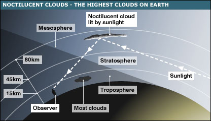
They are wispy, filamentary clouds that look a bit like an ethereal, crinkled veil. They can’t be confused with northern lights because they don’t move quickly and they are cyan in colour. In more southern locations, they are only visible as a trace on the northern horizon; here, they can take up a third of the sky, in a surprisingly bright and detailed display.
Long Summer Days
Another unique experience you’ll have in northern Alberta is the long summer days! The longest day of the year, the summer solstice, is 18 hours 23 minutes long. For about 35 days centered on the summer solstice, there are 18 hours or more from sunrise to sunset, which means that at local midnight, there is still plenty of twilight to enjoy — after all, the sun sets around 11 pm! The sun travels in a huge arc from rising in the northeast to setting in the northwest, reaching a maximum altitude of about 55 degrees. For more detail, check out the sunrise/set table from the US Naval Observatory) From mid-May to the end of July, we experience perpetual (nautical) twilight, which means that the sky never turns black, just indigo blue, with only the brightest stars visible.
The Madphilosopher weather page also has an annual temperature graph for High Level and Edmonton, to give you an idea of the temperatures you’ll encounter in this area. Some years are warmer than others, and although last year we didn’t hit 30°C much, we usually do!
Big Sky, Slow Sunsets

Tourists to this part of the world often remark at our “big sky.” We’re quite used to it, but with few obstructions on the horizon and clear air, our sky does look bigger than most. Also, our skies are bluer than in the south; the Sun’s lower position makes for richer blues overhead.
Due to our location on the Earth, we are blessed with beautiful, long sunsets and sunrises. Compare the angle that the sun sets for a location close to the equator (on the left of the illustration above) to the northern sunset (on the right). This is why our sunsets take, literally, hours. We have all the time we need to enjoy the beautiful oranges, pinks and reds.
Wildlife
There is an abundance of wildlife in this area: most commonly seen are whitetail and mule deer, moose, and less common, elk, caribou (reindeer), and even bison. Beavers, foxes, coyotes, and wolves are also abundant, not to mention birds.

Brown bears (also called black bears) are also fairly common, and we are on the edge of grizzly territory. We suggest you read more about bears before your trip — Bear Smart Society has many good pages. Lynx are occasionally seen and very occasionally, cougars.
We couldn’t talk about wildlife without mentioning mosquitoes! There are lots of them, swarms. From mid-May to the end of August, they are abundant. If you want to avoid them, paddle early or late in the season. Bring plenty of the mosquito repellent of your choice, avoiding citronella products as they may attract bears (see this page). Amazingly, once doused in repellent, you can somewhat adjust to the mosquitos! They are not usually a problem while paddling, just at camp in the evening. Pray, if you do, for a breeze to keep them at bay (if you don’t pray, you might want to start)! 🙂
Wilderness
Nowhere else in Canada can you experience this type of wilderness. Far from people, roads and airports, the world is quiet and peaceful. You will see helicopters and small planes occasionally, and high-flying airplanes will usually be the only man-made sound. This is backcountry camping at its best, and the “leave no trace” principles should be applied. When we’re camping at a remote site, we feel a kinship for the early explorers — the pioneers and voyageurs — making their way across an immense unknown wilderness.
Northwestern Alberta is covered in mixed Boreal forest. The main trees are white spruce, two types of poplar (aspen and balsam poplar) and jack pine trees. We also have extensive wetlands (lakes, sloughs, beaver ponds, creeks) and muskeg. Muskeg is essentially peat/boggy/soft ground, which may or may not be saturated with water, and which allows plants and trees to grow on/through it.
The info below is adapted from the Alberta Sustainable Resources Development (SRD) webpage (original page here):
Upper Hay
Introduction
Upper Hay—the northernmost of the 11 SRD management areas—is located along Highway 35 leading to the Northwest Territories. It shares its border with British Columbia to the west, the Northwest Territories to the north and Wood Buffalo National Park to the east. The region contains approximately 23 per cent of Alberta’s entire green zone and is about 83,000 square kilometres in size.
The area’s topography is predominantly flat with gently rolling sections. It is complemented by three distinct mountain ranges: Cameron Hills in the northwest, the Caribou Mountains in the northeast and the Buffalo Hills in the southeast. This part of the province consists exclusively of the Boreal Forest Natural Region.
Upper Hay includes the towns of High Level, Rainbow Lake, Zama City and Fort Vermilion. There are a total of 15 communities, 10 of which are First Nations communities.
The local economy
The resource-based economy in Upper Hay makes it one of the fastest growing areas of the province. The area’s abundant natural resources are balanced between the agriculture, forestry, and oil and gas sectors.
Area wildlife
Upper Hay supports the largest woodland caribou population in the province, as well as a nomadic herd of about 300 woods/plains hybrid bison. They inhabit the forest near the boundary of Wood Buffalo National Park.
Fishing is another major draw in the area with lake trout and northern grayling being among the most notable attractions.
For the naturalist, an abundance of wetlands support a variety of wildlife and one of the largest populations of breeding bald eagles in the province.
Tourism and recreation
The mighty Peace River meanders its way through the region, as do the Upper Hay River and the Chinchaga River. The region is home to a variety of parks, wildland areas and natural and recreation areas such as Buffalo River Recreation Area, Hay-Zama Lakes Wildland Park, and Watt Mountain Natural Area.
Other
There are 13 lookout towers located in the area to provide timely wildfire detection during the fire season.
The Peace River drops more than seven metres at the Vermilion Chutes or Falls near the settlements of Fox Lake and John D’Or Prairie. Early explorers had to portage around the chutes.
Dinosaur fossils have been found over the years east of High Level, and near the Peace River. Gravel excavations have exposed the remains of early woolly mastodons. The Peace River occasionally washes up old fossils.
The remains of petrified forests have also been discovered along parts of the Peace River.
York Boat Expedition | How to Use a Map | Planning Your Paddling Trip