If you’ve seen us around Alberta, you undoubtedly noticed our larger-than-life logo on the side of our Nissan Pathfinder, which we love!
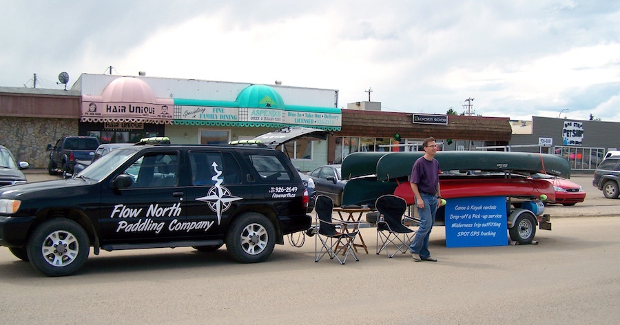
Promoting our business at the summer shopping event in downtown High Level
If you noticed it a couple of weeks ago stopped on the side of Hwy 49 north of Valleyview, or parked in a mechanic’s yard in Valleyview, well, let me tell you about a little winter adventure we had!
We were on our way to Edmonton to visit family and pick up a shipment of York Boat Captain books from our Canadian printing company. All was going well until the cruise control spontaneously went off. Then the ABS light came on, and the emergency brake indicator was flashing. We made a quick call to a mechanically-inclined friend of ours who told us the likely cause — the alternator or the battery. He figured we could probably go for a half hour or so, so we continued on.
We weren’t that far out of Valleyview, and we thought we could make it… and we came close! Our beloved Pathfinder came to a rolling stop about 10 km north of town. Thankfully, we were near a driveway, so we pushed it the last 10 metres or so to get it safely off the road. We walked up the driveway, hoping someone was home.
The woman who lived there was so kind! She quickly agreed to drive us into town to a hotel, and on the way, she told us her daughter works for the best mechanic in town! Uncanny. We took the name and number of the place, along with her suggestion of a tow truck driver to call. She said, “just tell them you’re at Susie’s north of town, and he’ll know where that is!” Gotta love small towns!
The hotel we chose turned out to the nicest, cheapest hotel in Alberta, I’m sure. I mean, where else can you get a really nice room for $79/night! In the morning, Darren and I walked over to Napa Auto Parts to see about a battery. A lovely lady named Charlotte stared searching on her computer to see if they had the right kind. Unfortunately, they didn’t (I had never noticed how batteries come in so many sizes), and they couldn’t find one at nearby Napa stores either. Meanwhile, a fellow who worked there, Dean, took a battery off the shelf and started measuring it. He figured he could make it work — it was a slightly smaller than we needed — so he offered to drive Darren out to the Pathfinder and install the battery to get us into town. No tow truck needed!
Well, the manoeuvre worked. The battery was much too small and the terminals were reversed, so to hook it up, Darren and Dean had to put it on an angle. It did the trick though, so Darren drove the Pathfinder to the mechanic’s shop. Dean, the bearded sweetheart that he is, didn’t charge us for the use of the battery, and came back to Napa to get me. The mechanic, Ken, put our battery on the charger to check its condition.
The battery was taking a charge just fine, so after 10 minutes or so, they put it in our vehicle to drive it into one of their bays. Now, make no mistake — the mechanic shop, called “MacKENics” after the owner, Ken, was completely booked. Ken, taking pity on us I suppose, still managed to help us out and it was determined that our alternator was dead.
Such a small part, but without it, wheels don’t turn. So, I continued the search I had started with Charlotte to find a replacement. The Nissan dealer in Grande Prairie was able to locate one at a Napa warehouse in Edmonton, so Charlotte ordered it for us. Darren got the idea that maybe our belts should be replaced at the same time. Ken agreed, so the belts were also ordered, and all the parts would arrive the next day. The only problem was the next day was a Saturday, and the mechanic shop is closed on Saturdays.
Ken didn’t even skip a beat when we realized it. He just called one of his mechanics who was having a day off and asked him to come in. So, while Darren and I had a leisurely morning, a guy who was supposed to be lounging at home came in and fixed our Pathfinder for us! We walked over and got it and were underway shortly after noon.
So, let me make a huge shout out to Susie, Charlotte and Dean at Napa, Ken at MacKenics, everyone at the Horizon Inn, and Ryan at the Grande Prairie Nissan dealership. Thank you so much for getting us back on the road! We actually enjoyed out little unexpected vacation in Valleyview. 🙂
Last weekend was an action-packed adventure weekend for us here at Flow North. We thought we would share the highlights of our trip to the town of Peace River for three busy days.
Thursday night: York Boat Captain Book Launch
I held my first official book launch for York Boat Captain – 18 Life-Changing Days on the Peace River with the help of the wonderful people over at the Peace River Museum, Archives and Mackenzie Centre. It went very well, as I expected, and it was a pleasure to chat with everyone, answer questions about the book and the boat, and see some old friends. (Blog posts here and here.)
Friday, Aug 16: Peace River Extreme Adventures Camp
As a part of the Paddle the Peace event, I teach canoeing for youth — a program we call Paddle the Peace Junior. Last year, the tiny rural school of Keg River benefitted from the program, and this year, it was offered for the youth of Peace River through the town of Peace River’s Extreme Adventures summer camp. We had an instruction day in July, which went very well, and this was the second one. Thanks to everyone at the town who made this possible — the kids all had a great time and learned canoeing skills, safety and even a little teamwork.
Saturday, Aug 17: Canoe Instruction
Paddle the Peace is actually a 2-day event for us; the first day is canoe lessons for adults. In order to accommodate more people, we have one group in the morning (lunch is provided) and another group in the afternoon (supper provided). We had such great people, in canoes and kayaks, who toughed it out despite the wind and waves on the lake! We reviewed canoe strokes, steering, teamwork, stability, getting in and out, and plenty of safety items, including a quick on-the-grass demonstration of the T-Rescue — a great way to help canoeists who have flipped.
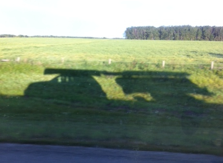
I love seeing the shadows of all the boats loaded on our vehicle and trailer.
Paddle the Peace: the Main Event! Sunday, Aug 18
As in years past, Flow North helps out by making canoes, kayaks and equipment available to people who need them! If a family didn’t have enough paddles, we lent them one. We lent PFDs to a mom for her kids. I always give the safety briefing on the bus before everyone goes out on the water, and with such a large group — about 100 paddlers! — I reminded everyone that it’s Sunday morning, so relax and be patient while others are boarding their boats. The whole process actually went very smoothly, as we staggered the departure of the two morning shuttles a little to eliminate a bottleneck of boats and people on the Shaftesbury shore.
A highlight of the day was the brunch at Strong Creek, provided by DMI, which allowed us to eat, chat and get to know one another. I think everyone agreed it was time well spent. On the whole, the day went remarkably well and nearly finished without any rain — just a downpour at the very end! My only regret: we were too busy to take pictures! Go to the Facebook page to see some posted there.
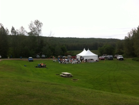
Looking down on the brunch tent and happy paddlers…
Let me not forget to thank everyone who worked so hard — over 20 volunteers — and funders who made the event possible. 🙂
– Shell Canada Peace River
– Daishowa-Marubeni International Ltd. (DMI)
– Travel Alberta
– Peace Regional Economic Development Alliance (PREDA)
Municipalities:
– County of Northern Lights
– Northern Sunrise County
– MD of Peace
– Town of Peace River
On Saturday, June 18th, my crew and I arrived safely in Fort Vermilion! There were a couple of hundred people there to greet us as we brought our boat to rest on that muddy shore. They’re all muddy shores it seems! 🙂 We left our campsite at Wieler’s Landing a little late, so we had to row pretty steadily for four hours to arrive on time. But hey, we’re hardened Yorkmen, so it wasn’t too tough!
The trip was absolutely amazing, and that was in large part due to the incredible crew I had! They had wonderful, positive attitudes, great senses of humour, strong initiative, keen work ethics, and were just the best damn crew a Captain could want! I have never before experienced teamwork like that, and I consider every member of the crew a member of my family now.
It wasn’t easy saying goodbye, but at least 2 of them live close by and we’ll visit often. I’ll be blogging lots more about the trip, and you’ll also be able to read about it in some magazine articles in the coming months.
NEW! York Boat Photo of the Day!
I’ve decided to share some of my photos with you, releasing one each day. Some are of the boat, some of the crew. Click for larger view. Enjoy!

Two days before the trip sets sail, Jae, Andre and Jack try on their costumes. Notice how *clean* the coats look!
Since Teresa is still on the water, I, Darren, am posting some of the latest pictures and information from the York Boat Expedition. The crew left Dunvegan, Alberta on June 1st, and they’re all set to arrive at Fort Vermilion on June 18th.
They’re having a fantastic time, being welcomed by communities and school groups all along their journey. The hospitality they’ve received has been wonderful.
You can read all about the York Boat expedition at the Geotourism Canada website, including scheduled stops.
There’s also a live progress map, a Facebook page, and a Twitter page.


| We’ve mentioned before that Flow North has been working with GeoTourism Canada to create a guide for the Peace River, and it’s almost complete! It will be available on GeoTourism Canada’s Go Vado! website in a couple of months, but we thought we’d give you a sneak peak.
We’ve written this guide to the Peace River to be both interesting and practical. From a practical standpoint, we’ve listed possible campsites and emergency road access, and 119 GPS waypoints for major stopping points, like boat launches, camping or rockhounding sites. Some major gravel bars and shallow areas are mentioned, but of course, the river is always changing and with river levels fluctuating because of the dam, it’s very hard to predict what areas will be problematic and what areas you’ll just float right over. Besides the practical stuff, we’ve also researched the history of the river, its landings and settlements, and included plenty of stories and geology. We know you will find this guide interesting and extremely useful! To help you plan your trip, have a look at the overview below, read this page about trip planning, and then call us to reserve your boat! The last column of the table below indicates distance paddled if you start in the town of Peace River instead of Hudson’s Hope. Of course, there are many places along the river that you can start from — contact us if you want more info — and you can calculate intermediate distances from the running totals. Guide #1 is about things to do in Hudson’s Hope, the starting point, and the paddling journey starts with Guide #2. |
 Hoodoos along the bank (near Taylor, BC)  Right side of The Gates near Hudson's Hope, BC |
| Guide # | Starts at | Ends at | Places along the way | Road access at the starting point? | km paddled | km from Hudson’s Hope | km from Peace River |
| 1 | Hudson’s Hope | Hudson’s Hope | W.A.C Bennett dam, Peace Canyon Dam | yes | 0 | 0 | |
| 2 | Hudson’s Hope | Halfway River | Lynx Creek, Gates, Farrell Creek | yes | 38 | 38 | |
| 3 | Halfway River | Island’s End | Bear Flat, Waterfall, Cache Creek | yes | 32 | 70 | |
| 4 | Island’s End | 101-km Campsite | Site C dam, Old Fort St. John, Taylor, 3 bridges | no | 31 | 101 | |
| 5 | 101-km Campsite | Driftwood Campsite | Beatton River, Raspberry Island, PR Corridor Prov. Park | no | 32 | 133 | |
| 6 | Driftwood Campsite | Cotillion Rec Area | Clayhurst Bridge, Pouce Coupe River, Clear River | no | 32 | 165 | |
| 7 | Cotillion Rec Area | Many Islands Park | Beverly (Deadman’s) Island | yes | 40 | 205 | |
| 8 | Many Islands Park | Pratt’s Landing | Montagneuse River, Carter Camp | yes | 41 | 246 | |
| 9 | Pratt’s Landing | Fort Dunvegan | Ksituan River, Dunvegan Suspension Bridge | yes | 28 | 274 | |
| 10 | Fort Dunvegan | Camp Island | Green Island, Long Island | yes | 42 | 316 | |
| 11 | Camp Island | Tangent Park | Kieyho Park, Peace Valley Guest Ranch | yes | 36 | 352 | |
| 12 | Tangent Park | Town of Peace River | Mackenzie Cairn, Strong Creek Park, several historic sites | yes | 24 | 376 | 0 |
| 13 | Town of Peace River | Graham’s Flat | Rail, highway and DMI bridge | yes | 32 | 408 | 32 |
| 14 | Graham’s Flat | Peace Island | Encampment Island, 30-mile well | no | 25 | 433 | 57 |
| 15 | Peace Island | Sunny Valley | Whitemud River, Cadotte River | yes* | 34 | 467 | 91 |
| 16 | Sunny Valley | McCracken’s Flat | Kulyna’s Flats | yes | 38 | 505 | 129 |
| 17 | McCracken’s Flat | Notikewin Provincial Park | Horseshoe Bend | yes | 42 | 547 | 171 |
| 18 | Notikewin Provincial Park | Beaver Campsite | pipeline crossing, nice beach | yes | 33 | 580 | 204 |
| 19 | Beaver Campsite | Cigar Island | Big Bend | no | 32 | 612 | 236 |
| 20 | Cigar Island | Old Carcajou | Howard’s Landing, Carcajou, Wolverine River | no | 33 | 645 | 269 |
| 21 | Old Carcajou | La Crete Ferry Campground | Armstrong Flat, Buffalo River, Keg River | yes* | 31 | 676 | 300 |
| 22 | La Crete Ferry Campground | Horse Point | Le Fleur’s Post, rockhounding, Horse Island | yes | 32 | 708 | 332 |
| 23 | Horse Point | Aspin House Area | Moose Island, La Crete Landing, Etna’s Landing | no | 36 | 744 | 368 |
| 24 | Aspin House Area | Wieler’s Landing | Hungry Bend, Gooseneck Point, Prairie Point | no | 40 | 784 | 408 |
| 25 | Wieler’s Landing | Fort Vermilion | Big Island, Lawrence Island, Highway bridge, Buttertown | yes | 28 | 812 | 436 |
yes* = Road access is not exactly at the starting point, but is there is access nearby (explained in detail in the guide).
Don’t forget to fill in our “Perfect Paddling Trip” Survey!
Well, my paddling for the summer is done — I finished paddling the upstream section of the Peace River last week. A friend of mine and her very cute dog came along this time, so I wasn’t solo. We canoed in one of our 16′ Paluski Fastwater canoes from Hudson’s Hope in BC to Peace River, a total of 375 km. We did it in 8 and a half days, averaging 44 km/day.

It was a great trip! We had a great time, although we experienced all that September weather has to offer. Overall, we can’t complain, as the only rain we got was at night (not counting a few drops on day 2). We had fall fog every morning, and it was pretty chilly at night. We definitely reached the limit — and beyond! — of our zero-degree-rated sleeping bags! Some hunters we met said that it had been -10 C overnight in a town nearby, so it was probably at least -7 C. That explained why we were so cold! We slept in all our clothes, wearing toques and scarves. We also had to wrap up the dog, and a couple of times she was shivering so much, Carolyn got the dog to climb into her sleeping bag to warm up. Little Buddy didn’t like that much — it was a long, dark tunnel to her! — but she didn’t have her winter coat of fur yet so she had to warm up somehow!

We had some pretty nice campsites overall. There’s a cabin at the Cotillian rec area with running water and a wood stove that’s open for people to use — we, unfortunately didn’t know about it until later and we didn’t see the access point. From the river, it just looked like a gravelly creek bed. But, we had a great time camping just the same! One night, in an established camp ground we met some wonderful people who shared their delicious supper with us — marinated steak, caesar salad and baked potatoes with fixings I’d never seen before! Birthday cake, wine, and elk sausage! Oh, we were in heaven! And great company too! Aaah, the bliss of food eaten outdoors, cooked on a fire, with friends! Nothing could be better. 🙂 We met some other nice people on our trip as well, including some hunters that were very generous to share their food and coffee with us. It was funny, because as we were just starting up the bank, we met a gentle, older fellow heading down to work on his boat. He said kindly “Hey, we ordered us a couple of girls!” I replied, “well… sorry we’re late!” It was cute! It wouldn’t have been as cute coming from a slimy guy, but from this grandpa, it was great. 🙂

The water level was still pretty low, and fluctuated quite a bit. Near Hudson’s Hope and the two dams the shores looked unnatural to me. The water levels went down 3 feet one night, causing us a lengthy portage the next morning. Another day, it went up about 2 feet. We were always glad to see the water level up, since it meant we wouldn’t have to worry quite as much about gravel/sand bars. We went the wrong way through a cluster of islands and ended up in a very shallow section one afternoon, where we earned our status as voyageurs. 😉
It’s hard to sum up 9 days in just a few paragraphs. It was fun, cool (literally), gorgeous, interesting, entertaining, and all that! And what I’ve learned will all be going into the Paddling the Peace guide I’m writing for GeoTourism Canada.
Well, I did it. I paddled by myself from Peace River to Tompkins Landing. If I’d had a little more time, I would have continued to Fort Vermilion, but with the Canoe Races at Hutch Lake on Saturday, I decided to come off the water a couple of days early to prepare. So, Wednesday, I sent frequent SPOT updates to Darren, as was our plan if I wanted to be picked up. It worked great. What an incredible journey!

Some stats about my trip:
– My GPS says 305 km paddled, but it was tracking while I walked around a bit too, so it’s probably about 295 km paddled or so.
– My GPS says I spent about 40 hrs 49 min moving and 20 hrs 28 min stopped. But I’m pretty sure it doesn’t account for time it’s turned off (at night, and at some stopovers, to save batteries).
– My gear weighed 86 lbs (39 kg). My kayak (a Prijon Kodiak) weighs 62 lbs (28 kg). I weigh 130 lbs (59 kg). Therefore, my arms and core body transported 278 lbs (126 kg) approx 300 km (the current helped). And I also lugged that 148 lb (67 kg) kayak up the shore repeatedly!
– I spent 6.5 days and 6 nights on the river.
– My average was 46 km per day. I aimed to do 50. This is considerably faster than the 10-day package (43 km/day), but in line with the 8-day package (55 km/day).
– I sat on shore through 2 thunderstorms, with nothing but a raincoat for protection! (That’s also why I didn’t make 50 km every day.)
– I used 1 bear-proof container, 6 dry bags, 1 mesh bag, and about 30 ziplock bags!

– Of the 6 times I camped in the wilderness, 4 times were completely away from people (more than 20 km?). The 2nd night I camped at Sunny Valley with a farm and cottages nearby, and the last night I camped on a new friend’s yard (wonderful Metis man I just met). 🙂
– I did all this with no rifle, only a can of bear spray, but I didn’t see any bears. It would have been a challenge to keep a gun dry….
– I didn’t lose or break a single item I brought along.
– I saw deer, moose, elk, wolf, various bird and beaver tracks. I saw actual deer, including some fawns, elk (one calf), beavers, bald eagles, other eagles/hawks. No wolves or bears — not even any bear tracks. That doesn’t mean there aren’t any, just that I didn’t see any.
– I heard all sorts of interesting sounds and birds that I wish I could identify!
It was a truly phenomenal trip, and since I did it alone, I had lots of time to think and reconnect to myself. I know it sounds a little corny, but in today’s hi-tech world and fast pace, we can get disconnected with ourselves, and taking time away to reconnect is so important. I am much more “the real me” now and far less stressed.
I’ve been adjusting to being back in society for almost a week now, and I’m feeling pretty well integrated again. My senses were pretty heightened, and I was more introverted than before, but I’m pretty well back to normal now. If you’d like to chat with me about my experiences, I’d be more than happy to share what I’ve learned and details for places I’ve camped. I’m working on a trip report that I will post on Canadian Canoe Routes, Paddling.net, Paddle Alberta and maybe a few other places. Once I’m done that, I’ll post the links here. I’m also planning on uploading a bunch of photos to Panoramio — I’ll post the link on this blog when I do!
